

The Port of San Francisco, which celebrated its 150th anniversary in 2013, invites visitors to explore 7.5 miles of scenic waterfront.
By Monica Poling
 For more than 250 years, San Francisco’s shores have attracted treasure seekers, fortune hunters and pioneers blazing brave trails into the new world. Vessels carrying all manner of passengers and goods, from clipper ships filled with gold-seeking prospectors to steamers loaded with exotic goods such as silk, tea, rice and opium, would pass through this golden gate to leave their mark on the growing city.
Today, the city’s vibrant waterfront serves as a cultural center and continues to captivate visitors with its once-in-a-lifetime views, pedestrian promenades, leisure activities, culinary offerings and world-class attractions. At the helm of this intricate leisure network is the Port of San Francisco.
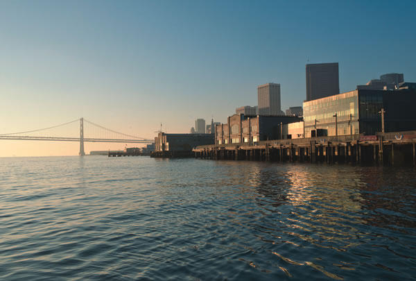
More than just an organization to facilitate cargo and commerce, the port—which celebrated its 150th anniversary in 2013—oversees 7.5 miles of the city’s shoreline, an acreage that is home to some of the city’s top leisure attractions: AT&T Park (home of Major League Baseball’s San Francisco Giants), the Exploratorium, the Ferry Building, Fisherman’s Wharf and Pier 39.
Early History
Long before San Francisco became a city, its shores attracted sailing vessels. The first ship to call upon San Francisco was the San Carlos in 1775. Although vessels had been plying California’s coastal waters for centuries before San Carlos’ arrival, none before had found a way to navigate the straight separating the Pacific Ocean and the San Francisco Bay with its foggy cloak, high winds and prohibitive swells.
It would take another 60 years before William A. Richardson would be appointed as the first harbormaster of the small community that was then known as Yerba Buena. For more than a decade, Yerba Buena would remain a quiet town of less than 1,000 people, attracting only a handful of vessels annually. In 1837, according to a report filed by Richardson, 25 ships entered San Francisco and left carrying approximately $75,000 worth of exported goods.
It was only in the mid-1800s that Yerba Buena began its transformation into a bustling commercial center. Almost immediately after the 1849 Gold Rush started—spawned by the discovery of gold at Sutter’s Mill in 1848—the port became a major point of entry into California, and that year alone saw more than 650 vessels carrying in excess of 90,000 passengers. The city’s population soared to 25,000 by year’s end.
Rapid development of the city, which was by then called San Francisco, came hand in hand with its increased marine traffic. The city’s first pier, Long Wharf (now known as Commercial Street) was built in 1848, and extended in 1850, and enterprising developers were quick to follow with additional construction.
In 1863, the state of California created a commission to oversee and improve harbor operations, and thus the Port of San Francisco was born.
Although the world’s fascination with gold eventually faded, the city’s allure never did, and San Francisco’s waterfront continued to attract traders, merchants and tourists. To handle the ever-increasing demands of cargo shipping, the State Belt Railroad was inaugurated in 1889, making it possible to load and unload cargo onto railcars situated on the piers.
By the early 1900s, the Port of San Francisco was home to 23 piers and was importing and exporting nearly 6 million tons of goods. With the opening of the Panama Canal in 1914 and the easy access it created for vessels traveling to the western U.S., the Port of San Francisco saw another significant usage spike. By 1922, cargo handling had catapulted to 14.5 million tons for the year.
The port’s extensive maritime infrastructure also made the city a natural hub for military logistics during World War II, and the waterfront became the headquarters for much of the war in the Pacific. In total, 1.6 million soldiers and 23.5 million tons of cargo were shipped to the Pacific from the Port of San Francisco during World War II.
By the end of the war, San Francisco had become the West Coast’s premier cargo port and, in 1969, the city and county of San Francisco took over the stewardship of the port.
A Modern Transformation
Today, the Port of San Francisco hosts much more than a passenger and container ship operation. Governed by a five-member commission, the port also oversees public recreation and manages more than 550 commercial leases, including popular destinations such as AT&T Park, Pier 39 and Fisherman’s Wharf.
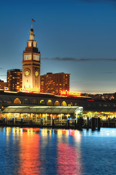
Among the port’s portfolio is a lease for the Ferry Building, an iconic San Francisco landmark, which was the primary point of entry into the city for area residents during the early 1900s. By 1930, some 250,000 ferry passengers would travel through the building every day—totaling 50 million passenger trips per year—making it one of the busiest transportation centers in the world. With the opening of the Golden Gate and Bay bridges, and the direct access they provided to the city, however, the Ferry Building fell largely into disuse.
Following the 1989 Loma Prieta earthquake and the subsequent removal of the double-decker Embarcadero Freeway that then blocked the front of the Ferry Building, the port was able to enact a plan to reconnect the waterfront with the city.
In 2003, after a four-year closure, the Ferry Building reopened as a mixed-use development with a popular public food market on the ground floor. The building continues to house the bulk of the city’s extensive ferry system, and nearly 11,000 commuters pass through it every day.
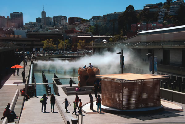
Ten years after the reopening of the Ferry Building, the port department continues to transform the waterfront into one of the world’s premier leisure centers. New at the port in 2013 was the highly anticipated opening of the city’s beloved Exploratorium. This science museum, originally housed in the Palace of Fine Arts, outgrew its prior home and sought space along the city’s waterfront.
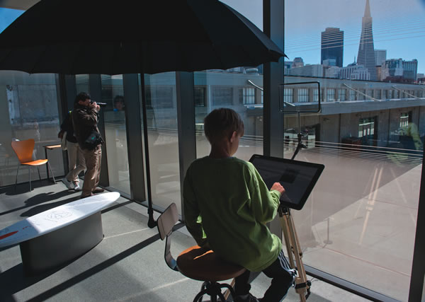
The new facility opened in April 2013 on a prime piece of real estate between Pier 39 and the Ferry Building. In addition to performing a complete renovation of Pier 15, the museum has taken full advantage of its San Francisco waterfront location, and offers visitors a unique look into the city’s watery ecosystem at its Bay Observatory Gallery.
“This two-story, all-glass structure has become a transparent lens to the waterfront and the cityscape, providing visitors an opportunity to observe the science of the bay, the landscape and the human impact that has shaped the Bay Area,” says Jenny Slafkosky, a spokeswoman for the Exploratorium.
The Exploratorium is also home to a series of pedestrian bridges that allow visitors to enjoy views of Pier 15, and it houses a number of unique public art pieces, including Fog Bridge, an installation that pumps water through 800 high-pressure nozzles, surrounding visitors in a misty curtain.
“I just love seeing people interact with the Exploratorium’s outdoor exhibits on the waterfront, especially Fog Bridge, which we just recently acquired permanently,” Slafkosky says. “It’s fun to see kids running through the mist, and adults watching the air currents swirl the fog around.”
Big Plans
As port officials look to the future, plenty of other developments, upgrades and renovations are in the works. Perhaps the largest in scope will be the 2014 opening of the James R. Herman Cruise Terminal, a two-level, 88,000-square-foot facility at Pier 27, which will handle the bulk of the city’s cruise line traffic.
The terminal was conceptualized in tandem with the announcement that San Francisco would serve as host of the 2013 America’s Cup sailboat racing competition. In advance of the competition in September, the port department demolished a maritime shed on Pier 27 and completed Phase I of the cruise facility construction, which subsequently served as home of the America’s Cup operations. Following the breathtaking, come-from-behind win for Oracle Team USA, port officials are now focused on rolling out Phase II. The special events facility and plaza will be used for maritime events such as Fleet Week, a tall ships festival, foreign naval diplomatic calls and visits by oceanic research vessels.
“After the America’s Cup moved out of Pier 27, the facility came back into the port’s hands on Nov. 1, 2013,” says Michael Nerney, maritime marketing manager for the Port of San Francisco. “Phase II of the cruise terminal construction, which includes the use of Pier 27 as a special event venue, is expected to be completed in fall 2014.”
In addition to its commercial, leisure and cargo business, the port manages an extensive network of parks, promenades and public lands, important space that provides breathing room and allows the general public to fully enjoy the city’s waterfront setting.
The port is also participating in the multi-agency Blue Greenway project, which aims to improve San Francisco’s southeastern waterfront portion of the 500-mile Bay Trail that stretches across a total of nine Bay Area counties. For the city, the plan is to create a “green” corridor along a 13-mile stretch, which will connect China Basin in the north to Candlestick Point State Recreation Area in the south.
In the meantime, individual projects are ongoing, such as the $26 million new park, Brannan Street Wharf, which is south of the Bay Bridge and features a lawn area and a small dock for kayaks and other leisure watercraft.
Visitors can enjoy much of the port’s green space on a leisurely walking tour that details the history of the Port of San Francisco. A series of 27 metal pylons dot the waterfront, displaying photographs and stories from the city’s vast maritime history.
With an ever-increasing lineup of the world’s premier attractions and increased opportunities for the public to enjoy views of San Francisco’s scenic landscape, the future is bright indeed for the Port of San Francisco. No matter what the future holds, one thing is certain: Adventurers are still welcome.


